Sometimes you see suprising things. During the spring run-off season two impressive falls appear on the east side of Middlebury Gap in Vermont's Green Mountains. As far as I know they have no name. They are also not particularly easy to approach. However, they are very interesting and worthwhile waterfalls.
In this document I will describe both of them, although I have so far only spent much time with one.
Both falls can be approached if you park your car at the turnout on the south side of Rt 125 located 4.4 miles west of Hancock and 1.9 miles east of Middlebury Gap. There are no signs. In the summer these falls are not visible from the road. In fact, I doubt if they even exist. However, both are visible from the road (if you are alert) during the time after the main snowmelt and before the leaves have grown on the trees.
There are two falls involved. The "upper" one is uphill from the turnout a short distance and relatively near the road. The "lower" one is downhill from the turnout about the same distance and well back from the road.
|
|
The Upper Falls |
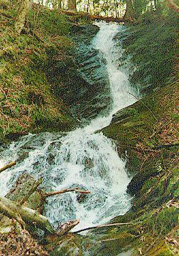
Overview: Approach difficult, but the falls are worth it.
Location: Hancock, VT
Stream  : Transient. Unnamed.
Height  : 100 feet.
Finding : Tricky. Near the road, but seasonal.
Access  : Bushwacking with a stream crossing.
Swimming: No.
Basking : No.
Legal   : In Green Mountain National Forest.
These falls were easy to see from the road today. They were, however, on the far side of the stream that paralled the road. To get to the falls, I had to cross that stream, and that was a bit difficult. With proper wading gear, it would have been easy enough, but the water was much too cold and swift to wade barefoot. I was able to get across by walking on a tree that had fallen over the stream, but I ended up getting a bit wet anyway.
 The falls cascaded down the steep ground toward the stream below.
The rocks around the falls were covered with vegetation, including many ferns that were
just starting to grow again after a long winter (spring came late to Vermont this year).
The ground was covered with large boulders and footing was difficult. It would have been
easy to accidently put a foot into a leaf covered crack between two boulders and break a
leg. I do not recommend that you approach these falls unless you are comfortable with
bushwack hiking over difficult terrian.
The falls cascaded down the steep ground toward the stream below.
The rocks around the falls were covered with vegetation, including many ferns that were
just starting to grow again after a long winter (spring came late to Vermont this year).
The ground was covered with large boulders and footing was difficult. It would have been
easy to accidently put a foot into a leaf covered crack between two boulders and break a
leg. I do not recommend that you approach these falls unless you are comfortable with
bushwack hiking over difficult terrian.
The falls were exquisitely beautiful, however. As the water splashed and played its way from rock to rock, it looked like a true deep forest waterfall cascading through thick, moist vegetation. It was the very icon of a mountain stream. Higher up the stream spilled into a large (20 or 30 foot) rock chute. As it did so, it arced outwards in a graceful curve. Truely, these falls were a wonderful find!
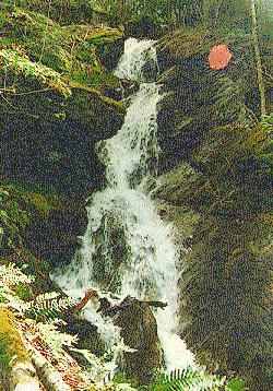
I have not yet investigated these falls although I have seen them from the road below the turnout. They are well back from the road but they appear to fall down the same formation as the upper falls I described above. The same stream needs to be crossed and then you would need to bushwack into the woods perhaps 100 yards to the falls themselves. I will try to check these falls out during the 1998 seasion.
Return to the list of waterfalls.