|
|
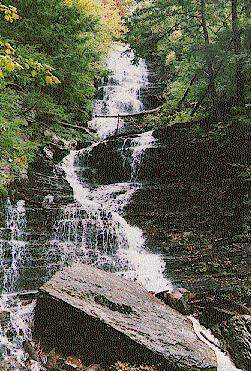
Lye Brook Falls |
Location: Manchester, VT
Height  : 100 feet (estimate)
Finding : Trailhead on a side road just outside of Manchester.
Access  : Moderate. Requires 2.3 mile hike (one way).
Swimming: No.
Legal   : Public lands. Inside Lye Brook Wilderness Area.
Stream  : Tributary of Lye Brook (I think).
These falls were first suggested to me by Diane Mead, a reader of this web site. She told me that "the hike is long and rather steep... but the view of the falls is worth it." She also directed me to the Manchester Highlands Inn page. They have a nice description there of the Lye Brook Falls hike.
Today was a cool (but not cold) fall day with clear air and a nice touch of color on the trees. Although there was a lot of blue sky around, the sky was thickly overcast all during my hike to and from the falls. Such is the nature of New England weather, I suppose.
Locating the trailhead was easy enough with the help of the fine directions provided by the Highlands Inn. Although the trail starts at the end of an obscure side road, it is well marked and obvious when you arrive. The trail itself is well tended and well travelled. Although it goes into the Lye Brook Wilderness, it was clear that the falls are a popular destination. When I arrived today the parking area was almost full.
The trail climbs gradually at first through a mostly Maple-Beech forest. After crossing through a windfall, it begins climbing more steeply. The area was beautiful. The forest was rich and green. The trail snaked dramatically along the side of the steep ravine and I could hear Lye Brook roaring in the valley below.
After about two miles of walking a well marked side trail diverged to the right toward the falls. This side trail held to a contour as it followed a very old railroad grade. I could just make out bits and pieces of old railroad ties rotting in the ground along the trail. The feeling that I was clinging to the side of a steep embankment was even more noticible along this section due to the narrowness of the trail.
After about 1/3 of a mile, I started hearing the falls ahead. Then, in only a few yards, the trail passed out from behind a rock face and into full view of the the falls.
They were wonderful! This was truely one of the highest waterfalls I've yet seen in Vermont. From a rock lip high above, the stream fell down over two major rock faces. The rocks were horizontally aligned layers causing the stream to take what looked like hundreds of small steps as it splashed from layer to layer.
The main distraction was that the trees on the other side of the lower portion of the stream had been blown over in recent times. As a result the lower part of the falls looked a bit torn up and unsightly. It would have been a much more senic spot if those trees had still been standing. However, I'm not offended by the work of natural forces, and in a few years the matter will probably have "corrected" itself.
I scrambled around on the rocks a bit trying to get a good picture, but it was hard to get a shot of the falls that would both show the entire waterfall and also give a sense of scale.
Highly recommended if you don't mind hiking.
Return to the list of waterfalls.