
|
|
Katahdin Stream Falls |
Overview: Excellent waterfall
Location: Baxter State Park, Maine
Stream  : Katahdin Stream
Height  : 30 feet
Finding : Easy
Access  : Requires hiking
Swimming: Impossible
Basking : Some possibilities
Privacy : Minimal; on a popular trail
Legal   : On public land
It was a beautiful day when I hiked up to Katahdin Stream Falls. The trail leftKatahdin Stream Campground on the southwest side of Mt. Katahdin. Getting to the trail head is not difficult, but it does take time. Mt. Katahdin is located in Baxter State Park which is in a relatively remote part of Maine. In addition, the park roads are very bumpy. Their speed limit is 20 mph, and if you value your vehicle I would suggest you observe that limit. As a result, it takes quite a bit of time to drive the eight miles or so from the park entrance at Tongue Pond to Katahdin Stream Campground.
The trail to the falls is the Hunt Trail. This is a section of the Appalachian Trail. In fact, the northern end of the AT is on the summit of Mt. Katahdin so end-to-end hikers coming from the south see Katahdin Stream Falls as the last waterfall on their long journey.
Although the trail to the summit is five difficult miles, the trail to the falls is only about 1.2 relatively easy miles. The first part of the trail runs alongside Katahdin Stream and climbs steadily but gradually. After about one mile, the trail begins climbing more steeply, crosses the stream, and shortly comes to the falls. The falls are right by the trail.
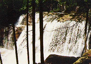 There are many interesting vantage points to view these falls. I scrambled down the
embankment below the trail some distance below the falls and got several interesting views
(see the picture at the top of this page). It was impossible to scramble all the way down
to the stream; it flowed through a narrow gorge with vertical walls some twenty feet high.
I suppose it might have been possible to wade up the stream from below. Although that
would have probably given a very interesting view of the falls, I didn't try it.
There are many interesting vantage points to view these falls. I scrambled down the
embankment below the trail some distance below the falls and got several interesting views
(see the picture at the top of this page). It was impossible to scramble all the way down
to the stream; it flowed through a narrow gorge with vertical walls some twenty feet high.
I suppose it might have been possible to wade up the stream from below. Although that
would have probably given a very interesting view of the falls, I didn't try it.
Farther up the trail it is easy to climb right down to the rocks next to the main part of the falls. In fact, I was even able to climb out onto the rocks and sit only a few feet from the full force of the cascade! Even farther up the trail, you can climb out onto the rocks at the lip of the falls. From there you get a good view of the gorge below and the world beyond.
The trail then turned away from the falls and continued its ascent up the mountain. A large white "4 Miles" sign was painted on one of the rocks indicating the remaining distance to the summit.
I spent an hour at Katahdin Stream Falls lounging on the rocks and taking pictures.
A very nice waterfall. Well worth the trip if you're in the area of Baxter State Park.
Return to the list of waterfalls.